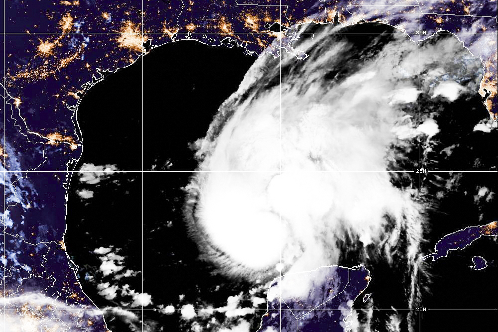

After nearly 130 days of relative calm, the 2026 Atlantic hurricane season birthed its first hurricane, and it’s headed for the Gulf Coast.
Emerging from near the Yucatán Peninsula as a tropical storm on Oct. 7, Hurricane Isaias swelled to a Category 2 storm with 100 mph winds by 5 p.m. ET on Oct. 8, and it is expected to make landfall somewhere between Florida’s Emerald Coast and the mouth of the Mississippi River sometime during the midnight hours between Oct. 9 and Oct. 10.
“We are bracing to have an impact probably late tomorrow night,” Florida Gov. Ron DeSantis said during a press conference in Florida’s Emergency Operations Center. “There will be tropical storm force winds before that, and it will likely continue into the wee hours of Saturday, and likely have some nasty weather follow on from that.
“So everyone: Execute your plan now. Heed your local authorities. You still have time to do it, but the time is running out.”
At 5 p.m. ET on Oct. 8, the National Hurricane Center tagged Isaias 325 miles south of the mouth of the Mississippi, moving northeast at 12 mph. Hurricane-force winds extend 15 miles from its center and tropical storm-force winds reach 125 miles out.
Hurricane warnings are also in effect from Ocean Springs to Florida’s Bay County–Gulf County line, and tropical storm warnings are in effect westward to the Jefferson Parish–Plaquemines Parish line in Louisiana, and eastward to Aucilla River, Florida. Tropical storm warnings also extend deep inland, extending north of Montgomery, Alabama.
A storm surge warning is in effect for the entire Gulf Coast between the mouth of the Mississippi River and the Suwannee River in Florida. The shoreline between Florida’s Indian River and Ocean Springs, Mississippi, including the entire Mobile Bay Area, is expected to receive five to seven feet of surge from the storm. A storm surge watch is also in effect for Florida’s coastline from the Suwannee River to Yankeetown.
The National Hurricane Center warned, “Preparations to protect life and property from storm surge and damaging winds in the warning area should be rushed to completion today.”
Preparations and Evacuations Underway
States of emergency are in effect for 25 Florida counties and 40 Alabama counties, and several of those counties are partially under mandatory and voluntary evacuation orders.
Residents along the coast from Alabama’s Dauphin Island and Orange Beach across Pensacola, Fort Walton Beach, Destin, Niceville, and the Barrier Islands of Franklin County, Florida, have been either asked or ordered to leave town.
Videos posted to social media showed bumper-to-bumper traffic on the northbound lanes of I-65 in Alabama, suggesting many residents are listening to their state leaders.
Several of those counties preemptively canceled school on Oct. 9, including Baldwin County, Alabama; Santa Rosa County, Florida; Okaloosa County, Florida; and Escambia County, Florida, which includes Pensacola. Airport closures or disruptions across the region also have already been announced or addressed.
DeSantis announced that the Florida Division of Emergency Management is preparing to respond to a Category 3 hurricane, even though the National Hurricane Center forecast only expects Isaias to become a Category 2.
“Most people think the wind shear is going to weaken the storm prior to making land from. Let’s hope that’s the case,” he said. “But I also remember—and the conditions are different—but in 2018, eight years ago, there was a storm called Hurricane Michael. A lot of people didn’t even know it was going to be a hurricane. Then all of a sudden, it got very strong.”
Hurricane Michael was one of the most destructive storms to hit the Panhandle in recent memory.
“We’re going to prepare as if the shear isn’t going to do that,” he said.
Expected Impact
The governor emphasized that the Panhandle was expected to receive the “dirty side” of the storm. Hurricanes spin counterclockwise, which means that the worst wind and surging waters are on the storm’s east side.
In fact, a significant portion of Florida’s Gulf Coast is expected to face some level of storm surge due to that spinning. Even the Tampa Bay area could see water levels one to three feet above normal dry land.
Meanwhile, tropical storm-force winds are expected to arrive onshore by the morning of Oct. 9, and hurricane-force conditions are expected to arrive later that day into the early morning of Oct. 10.
Rainfall throughout the event is expected to be more than six inches across the region, from Southeastern Louisiana through the Florida Panhandle, with isolated areas of 15 inches. Several inches of rain are also expected in other parts of the inland South, including Georgia and the Carolinas.
That rainfall will add to the significant amounts Florida received in the past week, which means that rising water has been projected not only from the coast but also along rivers and other inland areas.
“We’re going to be watching all of the local rivers, streams, creeks, even closed drainage systems and subdivisions,” said Jared Perdue, executive director of Florida Division of Emergency Management. “We’re going to be watching those water levels and doing everything we can to help people stay safe.”
The National Hurricane Center warns that as the rain bands make their way inland, the chance of tornadoes also increases, and a potential risk looms from the evening of Oct. 9 through Oct. 10 for Alabama, Georgia, and the Florida Panhandle.
Record-Setting Storm
Isaias’s arrival follows a record-setting calm start to hurricane season in the Atlantic Basin, which includes the Atlantic Ocean, Sargasso Sea, Caribbean Sea, and the Gulf of America.
Its hurricane season begins on June 1 and ends on Nov. 30, but this season is the first since 1914 during which no hurricane has formed in the Atlantic until now, and 1914 is one of only two years on record during which there were no Atlantic hurricanes. The other year was 1907.
Isaias is the latest first hurricane since the satellite era began in the 1960s. The latest first hurricane of all time was in 1905, when the first hurricane formed on Oct. 8, so that record survives by only a few hours.
Jack Phillips contributed to this report.