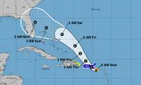
Hurricane Dorian has formed and is expected to impact the United States.
The U.S. National Hurricane Center (NHC), in its 2 p.m. update, said Dorian formed on Aug. 28.
The storm, a Category 1, currently has 75 mph winds and is moving northwest at 13 mph, the agency said.
Dorian’s cone of probability suggests that the storm could move north of the Bahamas and make landfall in Florida.
Hurricane warnings are in effect for the U.S. Virgin Islands, the British Virgin Islands, and Vieques and Culebra. A hurricane watch is in effect for Puerto Rico, which is also under a tropical storm warning.
On its current track, “Dorian should continue to move near or over the U.S. and British Virgin Islands this afternoon and then move over the open Atlantic well east of the southeastern Bahamas,” the NHC wrote.
Dorian is predicted to strengthen over the next several days as it moves across Atlantic waters.
11 a.m. #Dorian update:
Winds have reached 70 mph, and this could now become a Category 3 hurricane by Sunday morning. pic.twitter.com/xVBa0x8Ufk
— The Weather Channel (@weatherchannel) August 28, 2019
In terms of rainfall, the storm is expected to dump 4 to 8 inches in parts of the United States and up to 10 inches in other isolated areas.
Meanwhile, “Swells are expected to increase later today across the U.S. and British Virgin Islands and along the southern coasts of Puerto Rico and Hispaniola, and they could cause life-threatening surf and rip current conditions. Please consult products from your local weather office,” the NHC said.
Dorian prompted President Donald Trump to declare a state of emergency Tuesday night and order federal assistance for local authorities, The Associated Press reported.
Tropical Storm Dorian hit the island of Martinique, causing a road collapse, street closures, severe flooding, and trapping a bus. It’s possible that the storm may strengthen to a hurricane as it approaches the Florida coast this weekend. https://t.co/VG30LJ09vR pic.twitter.com/1nEEDDyGpt
— ABC News (@ABC) August 28, 2019
Virgin Islands Hit
At 2 p.m. EDT, Dorian was located over St. Thomas in the U.S. Virgin Islands. The U.S. National Hurricane Center said it had maximum sustained winds of 75 mph (120 kph) while moving northwest at 13 mph (20 kph). The Hurricane Center said the storm could grow into a dangerous Category 3 storm as it pushes northwest in the general direction of Florida.
In the U.S. Virgin Islands, which is still struggling to recover from hurricanes Irma and Maria, officials were reporting power outages and light rain by 1:30 p.m. EDT.
Based upon current forecast models, this is pretty much what we’re expecting Hurricane Dorian to look like by Sunday (or earlier). Major hurricane with an eye … slowly creeping toward the coast over the very warm Gulf Stream.
Treacherous FL Atlantic beaches this weekend. pic.twitter.com/ANupbcDZI7
— Ryan Maue (@RyanMaue) August 28, 2019
“Winds have picked up significantly. We’re starting to get some of those heavier gusts,” the governor’s spokesman, Richard Motta, said in a telephone interview.
The Associated Press contributed to this report.